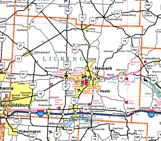
Ghost Towns of
Licking County


Licking County is located just east of Franklin County and is the home of Newark, Granville, and Pataskala. The old National Road ran through Licking County, as does Route 40 today. It's the home of popular tourist attraction and Jimmy Buffet venue Buckeye Lake. I visit Kirkersville every summer to buy fireworks at the outlet store there. I've also done some research into the many ghost towns in Licking County. If the spread of Columbus continues at its current rate, I think we'll see many more towns give up the ghost in years to come.


Ash
Jersey Twp.
Crossroad community.
Ashbrook
Jersey Twp.
A town which had a post office for three months within the span of one year: from January 21, 1892 to April 12, 1892.
Atherton
Licking Twp.
Located at the intersection of Ridgely Road and the Buckeye Scenic Railroad, this town was a stop on the Baltimore and Ohio spur to Buckeye Lake. Post office opened in 1884 and closed in 1925, when the name was changed to National. Today there are a few piles of bricks to mark the place where Atherton once stood.
Avondale
Licking Twp.
Town located on the northeast end of Buckeye Lake along Avondale Road near Licking Road. It was a railroad station for the Strightville Division of the Baltimore and Ohio Railroad at Buckeye Lake. There was a popular resort located there known as the Avondale House.
Beech
Located at the intersection of Beech Road and State Route 161, Beech was a small post office community. The P.O. operated from 1858 through 1899.
Ben
Licking Twp.
Crossroad community located at a jog in Montgomery Road between Bolen and Loper Roads. P.O. operated here 1895-1902.
Benjamin
Union Township
A little town named after settler Jonathan Benjamin. A schoolhouse was located here between 1808 and 1810.
Blanchard Settlement
Granville Twp.
Located on the road from Granville to Mt. Vernon (S.R. 661), near the southern border of McKean Township.
Bloodhill
St. Albans Twp.
A "house of entertainment" was opened here in 1813 by Asa Plummer, who sold it to William Mills in 1814. In 1817 it was sold to Frederick Blood, the town's namesake, who then opened the first hotel in the township.
Brushy Fork
Perry Twp.
Located near Brushy Fork Creek, a post office operated here from February 26, 1863, until August 3, 1863.
Cannonsburg
Newton Twp.
Located on the southern bank of the Brushy Fork Creek, three miles north of Newark on Mt. Vernon Road. It was originally known as Fairfield and was laid out by Judge Elliott in 1805. The change to Cannonsburg was to honor the town's tavern keeper, Thomas Cannon.
Claylick
Madison Twp.
The interesting name of this village is said to have arisen when pioneer Henry Johnson first came to this area he observed deer licking at the salty clay along the riverbank. The post office here operated from 1852 until 1981. Two families, the Johnsons and the Hickeys, owned the stores and mills in the town. Claylick contained a gristmill, a sawmill, a railroad station for the B & O line, a blacksmith shop, a cream station, a couple of general stores, and a post office. There was also an interurban station about a quarter of a mile north of town. The sawmill was water powered long after such a power source had gone out of vogue, and used a vertical saw blade to cut railroad ties. Eventually Claylick was killed by floods. The disastrous 1913 flood destroyed the main industries in the town--the sawmill and the gristmill--and the 1959 flood finished the job by convincing the U.S. Army Corps of Engineers to build a dam and floodplain there. They used eminent domain to buy the town.
Clemons Mills
St. Albans Twp.
Located on Mootz Run, this town was the site of a sawmill contructed in 1818, the miller's house, a small store, and an artisan well used to produce salt.
Cokesbury
McKean Twp.
Named for Thomas Coke and Francis Asbury, this town was located at the intersection of Liberty Church and Dutch Lane Roads. There was an Episcopal Methodist Church established here in 1820, and a post office between 1851 and 1853.
Cook Settlement
Bennington Twp.
Formed after the War of 1812 by Titus Knox and Captain Cook. A schoolhouse built in 1828 was later used as a meetinghouse for a religious society called the New Lights. In 1835 they built themselves a church, and in 1875 put up a new one. Their current status is unknown.
Cooksey
Perry Twp.
Now the village of Reform, a P.O. operated here from 1880 to 1889.
Denman's Crossroads
Perry Twp.
At its peak this town consisted of six families, a general store, a blacksmith shop, and a shoe shop. The Denman family, according to legend, was once attacked by a bear at their home, but saved by their dog.
Dogtown
Newark Twp.
Now consumed by Newark, this town was located on the east bank of the north fork of the Licking River in Newark. Local legend states that this town was the home of a race of half-man, half-dog creatures.
Egypt
Fallsbury Twp.
Located along the Wakatomika Creek. A mill once stood here, as did a Methodist Episcopal Church.
Frampton
Fallsbury Twp.
Located at the intersection of Frampton and Anderson Roads. P.O. operated between 1884 and 1901. Today Frampton is marked only by a millstone imbedded into the wall of a bridge abutment.
Frazeyburg
Madison or Hanover Twp.
Founded in 1827 by C. Hollenback, Frazeyburg was an oil town in the 1860's. The canal and the railroad ran through it. In 1870 its population was 485.
Gilbert's Mills
Fallsbury Twp.
Located on the Wakatomaka Creek, this town once contained a gristmill and a sawmill framed in hemlock. It once contained a copper shop, blacksmith, general store, and a post office.
Green
Monroe Twp.
Located at the intersection of S.R. 37 and County Line Road. The P.O. here was opened, closed, and re-opened several times between 1857 and 1893.
Hammertown
Madison Twp.
This town grew up around the blacksmith and wagon shop, both of which were house in a long, low building on the old Furnace Road.
Hanover
Hanover Twp.
Located on the east side of Rocky Fork Creek, this town dates back to 1808, when a gristmill opened on the creek and a tent camp sprung up around it. The town was then called Hollister's Mill. More stores were built, and permanent housing sprang up. The town's name was ultimately changed to Hanover, after the city in Germany, so the town could get a post office. The canal passed through Hanover, and for a while it was an important city, handling lumber and stone shipments. A railroad also ran through. Hanover was also called Natchez Under the Hill because it was a haven for highwaymen, horse thieves, and counterfeiters. When the Dillon Dam project began in 1960 the town was taken over and a new Hanover grew up north of the old town.
Harbor Hills
Licking Twp.
Post office town, operated between 1927 and 1943.
Henpeck
Fallsbury Twp.
Located at the intersection of S.R. 586 and Rainrock Road, this oddly-named town had only one business: a store, operated by Wheeler Johnson.
Hoyt
Hanover Twp.
This town was built in 1832 around a store built by John Hoyt, but died when the railroad failed to come through the town. It was located along Schenck's Creek.
Little Bowling Green
Bowling Green Twp.
This town was a small prairie located one mile south of Linnville. A tributary of Jonathan's Creek runs through it. In 1802 a group of West Virginia frontiersmen established a settlement there.
Little Claylick
P.O. operated between 1878 and 1883; located at the intersection of S.R. 668 and Cooks Hill Road.
Lockport
? Twp.
Town built around canal locks, one of which is still there and marked with a historical plaque. The town dates to at least 1871.
Long Run
Eden Twp.
Long Run was alternately known as Longrun, Colville, and Oberlin, and was located at the intersection of Long Run and Rain Rock Roads. It consisted of the Edwards Meeting House, a mill, a church, and several houses.
Mary Ann Furnace
Mary Ann Twp.
Located at the intersection of Hickman Road and County Road 243, along the banks of Rocky Fork Creek. In the early 1800's a high grade of iron ore was discovered in the hillsides of Mary Ann Township. A sawmill was constructed in 1815 out of sandstone, and lumber was cut to feed the furnace. Next, the furnace was built, named for founder David Moore's wife Mary Ann. The furnace was the first industry in Licking County, and it continued operating for the next forty years. It was famous for its ornate cookstoves. Workers wore brightly colored uniforms and were paid fifty cents for two weeks work. The town was so prosperous that it was once considered a candidate for the county seat. Then, in 1860, the furnace burned down (how's that for irony?). For years a pile of rocks was visible where it had been, but that's long gone. Now there's a house which once served as a tavern and an operating school.
Melgren
Located at the intersection of U.S. 40 and Somerset Road, this post office town operated from 1888 through 1901.
Morus Hill
Eden Twp.
P.O. town; 1842-1849.
Moscow
Licking Twp.
Two miles east of Hebron on U.S. 40, this town was the site of the Moscow Mill, erected in 1830 on the south fork of the Licking River. Today only a bridge remains to mark the site of the town.
National Road
Licking Twp.
This town was once called Atherton. Its post office operated between 1925 and 1934.
Newton Mills
Newton Twp.
Located half a mile south of St. Louisville at the intersection of the North Fork of the Licking River and S.R. 13. It replaced Houston Mills and operated from 1828 through 1837.
New-Way
Liberty Twp.
A post office once existed here, at the intersection of Loudon Street and Sportsman Club Roads, at Brushy Creek. It never consisted of more than a half-dozen homes.
Nicholastown
Mary Ann Twp.
Site of a sawmill, gristmill, and store. The town existed from 1858, when Thomas Nicholas built the store, through about 1909.
Purity
Eden Twp.
At the intersection of Eden Church and Purity Roads stood the town of Purity, where the post office operated between 1888 and 1904.
Raccoontown
Monroe Twp.
Located along S.R. 37, above Johnstown along Raccoon Creek, near the Greenhill Cemetery. The town was bought in 1807 by Charles and George Green from the Wyandot Indians.
Rain Rock
Eden Twp.
Rain Rock today is a field where it looks like it has just rained big rocks. It can be found at the intersection of Bodle and Rain Rock Roads.
Reservoir
Licking Twp.
At the intersection of Cristland Hill and Jacksontown Roads, the Reservoir post office operated between 1886 and 1888.
School Land
Hartford Twp.
This town was located at the intersection of School Lane and Downing Roads, on the "school land" half of Hartford Township--the half designated by the U.S. government for schools. A cane mill was built here, and a post office operated between 1865 and 1880. An interesting part of School Land history is the 1855 church which Nathan Yearly leased to the Universalists. He stipulated that anytime the Universalists weren't using the church, they had to let any other denomination use it. Lots of other religions took advantage of this--among them the "New Lights" of Cook Settlement fame. They were also referred to as the "Dunkard People," since their denomination placed special emphasis on baptism. The church was later rededicated and moved to the Hartford Fairgrounds.
Scott's Corners
St. Alban's Twp.
Located at the intersection of Worthington Road (S.R. 161) and S.R. 37, this town was the site of the first church in St. Alban's Township, built in 1824. The church was later split into a school and a residence.
Squawtown
Washington Twp.
Located two miles east of Utica, this town got its name from a grisly incident in its history. A Mr. McLean and Mr. Hughes one day played cards there to see who would get to shoot a squaw. McLean won and shot the squaw. He later spent a whopping two years in the state pen for murder, and died shortly after his release.
Stinger
Burlington Twp.
P.O. town; February 21, 1895-September 30, 1895.
Tilton's Crossroads
Fallsbury Township
Ghost town located at the intersection of Priest Hollow and Ridge Roads.
Welsh Hills Settlement
Granville Twp.
Located two miles northwest of Newark and etending into McKean Township, this area was five or six miles long and four miles wide. The first settlers arrived here in 1802. A Baptist Church was erected here in 1808. Today the town is marked by Welsh Hills Road and the Welsh Hills Cemetery.


Back


Sources

Helwig, Richard. Ohio Ghost Towns No. 44: Licking County. Sunbury, OH: Center for Ghost Town Research in Ohio, 1998.

Ohio Atlas and Gazetteer. Yarmouth, ME: DeLorme, 1999.