Ghost Towns of
Franklin County


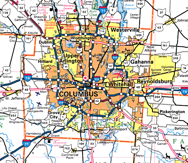
Franklin County is the home of Columbus, where I live, and it's also the home to hundreds of ghost towns, most of which were absorbed by Columbus as it expanded. This is an ongoing process--dozens of outlying communities are in the process of being annexed and homogenized as Columbus spreads like a deadly plague. Okay, maybe that's a little harsh, but it still sucks that many of these towns are no longer identifiable as anything more than a stretch of freeway or an intersection littered with corporate gas stations.


Ackerman
Clinton Twp.
The existence of this railroad town is marked only by the existence of Ackerman Road north of the Ohio State main campus.
Alton Station
Prairie Twp.
Railroad town which served the town of Alton on the west side of the county.
Alum Creek
Mifflin Twp.
A crossroad community on the banks of Alum Creek, this town existed in the late ninteenth century.
Amalthea
Blendon Twp.
AKA Central College (see below).
Amlin
Washington Twp.
Railroad town today located on Rings Road at the Conrail tracks, between Cosgray and Avery Roads
Bannon
Marion/Hamilton Twp. line
Railroad town.
Big Walnut (1)
Mifflin/Truro Twp. line
Railroad town.
Big Walnut (2)
Hamilton Twp.
Railroad town.
Billy Wyandot's Camp
Washington Township
An Indian village located about one mile north of Dublin on the banks of the Indian Run River. Many of the 150 Indians who resided here in 1809 enlisted in the army under president William Henry Harrison during the War of 1812. Among these was Captain Turtle, who went on to participate in the Battle of Tippecanoe. Their chief was known as Billy Wyandot. The daughter of the man who owned the land--Samuel Sells--once caused a panic by taking shooting lessons during the day. Her mother heard the shots and raised the alarm: "the Indians are coming!" Nearby settlers headed for Franklinton, but Sells' daughter quickly explained and calmed things down.
Blendon Four Corners/Blendon Corner
Blendon Twp.
This crossroads community was located at the intersection of Granville Road and the Columbus-Westerville Pike. It was originally known as Harrison Post Office, until Harrison Township was changed to Blendon Township. The first tavern in Blendon Township was opened here in 1921 by Francis C. Olmstead. The residents were then offered a depot if they could raise $500 to build it. The money was raised and a depot and Y-track was placed in Blendon Four Corners.
Briggsdale
Franklin Twp.
Railroad town.
Brice
Truro Township
Brice still exists--sort of. There's Brice Road, and there's a section of southeast Columbus which tries to hold onto its identity as a small town, but it's basically a part of the city now. Brice grew up around the railroad in the late ninteenth century.
Bright
Hamilton/Madison Twp. line
Railroad town.
Bronsons
Norwich Twp.
Railroad town.
Brownsons Station
Norwich Twp.
Railroad town.
Bruce
Truro Twp.
Burdell
Madison Twp.
Railroad town.
Caldwell
Truro Twp.
Railroad town.
Camp Chase
Franklin Twp.
Confederate POW camp now located on Sullivant Avenue on the west side of Columbus, marked by the old Camp Chase Confederate Cemetery.
Camp Jackson
Franklin Twp.
Military post.
Central College
Blendon Twp.
Located south of Hoover Dam on Sunbury Road. Amalthea took its name from mythology--the goat that nourished Jupiter. In the 1820s and early 1830s Ebenezer Washburn conducted a school at Amalthea, teaching "the rudiment of the classics," psychology, ethics, "Butler's Analogy," and higher mathematics. In 1835, Squire Timothy Lee, who owned much of the land, offered 100 acres to the Presbyterian Church for the establishment of an institution of higher learning. Thus was born the Blendon Institute, which got its post office on September 23, 1841. Lee built four college buildings for the new school: a three-story brick dormitory, a dwelling house, a recitation building, and a chapel. Reverend L.A. Sawyer was the college's first president, with Ebenezer Washburn relegated to assistant duties. In 1842 the school changed its name to Central College. Stores, blacksmiths, and millers opened up shop in the area, kept in business by the college, which flourished briefly, only to lose business to the other schools which cropped up in the state capital nearby--not the least of which was Ohio State University. By 1901 Central College had closed its doors. For a while a home for the blind occupied the buildings; today they're used by the city of Westerville for public functions.
Clover Settlement
Prairie Twp.
Town formed by the Clover family, who were from Ross County and, before that, Virginia, in 1913. The family had ten sons and two daughters. Two of the boys--Peter and Joshua--were known as the "brag hunters" of the area, and Peter was eventually the first Justice of the Peace elected in Prairie Township. In 1858 all that was left of Clover Settlement was a Methodist Church.
Crane's Village
Norwich Twp.
An Indian town located on the west bank of the Scioto River in northern Franklin County. An exclusive men's club called the Wyandot Club was formed at the same place years later.
Darby P.O.
Brown Twp.
Post office community formed around the private Darby P.O., which operated from 1848 to 1862.
Darby Park
Prairie Twp.
Railroad town now marked by the location of the Darby Metropark.
Deem's
Prairie Twp.
Railroad town.
Doneys
Truro Twp.
Railroad town located in northwest Truro Township.
East Columbus
Mifflin Twp.
An eastern portion of Columbus which was once its own town, much like East St. Louis. East Columbus was located in the southeast quarter of Mifflin Township on the Pennsylvania Railroad, and was known at various points in the past as both Dakrumm and Rarigville. Its post office was eastablished in 1905 and discontinued in 1937, when it became a substation of the Columbus P.O. In 1930 the Ralston Steel Company Works was located here, as was a large military storage plant.
Eastwood
Montgomery Twp.
Crossroad community.
Edgewater Park
Madison Twp.
Located south of Refugee Road on Route 317/Hamilton Road.
Edward
Madison Twp.
Railroad town also known as Edwards Station which was located along what is now the Chesapeake and Ohio Railroad, just across the township line from the Columbus Motor Speedway. When it was built the line was the Hocking Valley Railroad. The P.O. operated from 1874 through 1898.
Ellison
Hamilton Twp.
Railroad town.
Evanston
Clinton Twp.
Also known as North Broadway; marked today by the street with this name.
Fishingers
Washinton Twp.
Crossroad community.
Five Mile Siding
Clinton Twp.
Railroad town.
Flint
Sharon Twp.
Railroad town located at South Old State Road and Park Road, near US23, north of Columbus. Today marked by the boarded-up Flint Park school and a small park. Also known as Westerville Station or Wester V Station.
Franklinton
Franklin twp.
Franklinton today is known as the Bottoms, an economically depressed section of town just west of downtown Columbus. Although it's hard to tell, this town pre-dates the city which has smothered it by a good fifty years, and was one of the first settlements west of the Ohio River. It was founded in 1797 by Lucas Sullivant, who decided on the site because he found fertile Indian cornfields in the lowland on the west bank of the Scioto River. He laid out the first street, which he called Gift Street, because parcels of land would be given to people who chose to settle in the largely untamed area. A town grew up as people moved in; a hotel, a jail, and a general store were built. When a capital city was to be created for the state of Ohio, Franklinton was a contender, helped along by its geographically central location. However, Franklinton had--and still has--one major drawback: floods. The lands flooded regularly, so the new capital was laid out on the high bank of the Scioto and named arbitrarily for Christopher Columbus. My dad still remembers the times when the Bottoms flooded in the 1960s; he said you could drive on I-70 and see the damage. Today Sullivant is remembered by two major Columbus street names, but Franklinton is buried; not a single original building remains of the settlement.
Gordonia
Pleasant Twp.
Gould Park
Blendon Twp.
Located south of 161 on Big Walnut Creek.
Grandview
Franklin Twp.
Railroad town now known as a section of Columbus.
Grogan
Clinton Twp.
Crossroad community.
Guthrie
Hamilton Twp.
Railroad town.
Havens Corners
Jefferson Twp.
Crossroad community located on what is now Havens Corners Road near Blacklick Creek.
Hayden Falls
Perry Twp.
Railroad Town.
Hibernia
Truro Twp.
A crossroad community formed when Thomas Armstrong sold several lots of his property near "the crossings of Walnut Creek." The place was never meant to be a town but grew into one, with a post office operating between 1849 and 1857. Today an interesting relic remains of Hibernia in the Hibernia apartment complex. Located on East Main Street just west of I-270.
Highway
Norwich Twp.
Railroad town.
Kenner
Norwich Twp.
Railroad town.
Lamb Corners
Washington Twp.
Located near State Route 33 at the Union County line.
Lane Avenue
Perry Twp.
Also known as Lanevue and then Seagrove, this town grew up around a stop on the Toledo Division of the Hocking Valley Railroad. Its post office only operated two years, from 1898 through 1900. Today it's remembered by Lane Avenue in north Columbus.
Lislie
Prairie Twp.
Railroad town.
Maple Heights
Clinton Twp.
Railroad town.
McCoy's Mills
Perry Twp.
This town was located on the banks of the Scioto in Perry Township. Thomas Bakus built a flouring mill here about 1813 or 1814. It was later known as Matere's Mills and Marble Cliff Mills, and served area settlers for years.
Miner
Hamilton Twp.
Railroad town.
Mounds
Norwich Twp.
Railroad town.
Mudsock
Norwich Twp.
Established in the 1850's, Mudsock was named for its muddy streets. A farmer once lost his shoes and socks in the mire after his horse got stuck, and the town was named. A Methodist Church was established here in 1876. When it came time to name the church the townspeople got one vote each, to be submitted with five cents. Ann Colwell, wife of church founder John Colwell, bought $25.00 worth of votes--so the church was called the Colwell Methodist Church. Today the place where Mudsock was located is an intersection on Roberts Road on the west side of Columbus, near Reebok Drive. Margaret Yost wrote an article on Mudsock in 1956, and Randy McNutt profiled it in his book Ghosts.
Munks Corners
Truro Twp.
Small town that existed as recently as the 1950s, at the corner of Refugee Road and Winchester Pike.
Nigger Town
Hamilton Twp.
Before you get mad at me for including this one, try to remember that the word didn't always carry quite the same negative connotations. Fair or not, this town grew up at a location near what is now the Alum Creek Drive exit on I-270 south.
North Columbus
Clinton Twp.
Located between Clintonville and Columbus, this town was established in 1852 and annexed in 1872.
North Liberty
Franklin Twp.
Another town laid out by Lucas Sullivant, this one along the banks of the Big Darby Creek around 1799. It was the second settlement in Franklin County.
Oakland
Jefferson Twp.
Crossroad community.
Olentangy Station
Perry Twp.
Located on the Toledo Division of the Hocking Valley Railroad. In 1830 John McKay started a brewery just south of Olentangy Station. After it stopped operating it survived as a private residence for a while before being destroyed by fire. The post office here operated from 1878 through 1904.
Parks Mill
Mifflin Twp.
Town located on Alum Creek, near Sunbury Road and McCutcheon Road. Its post office operated from 1851 through 1853.
Pinhook
Blendon Twp.
Located at the intersection of Granville Road and the Columbus-Central College Pike, on the banks of the Big Walnut Creek. Pinhook got its name when a local man named Layman Day commented that the town's founding father was so stingy that the devil could catch his soul on a pinhook baited with a five-cent piece. The name stuck somehow, and the town of Portersburg was changed to Pinhook.
Pleasant Corners
Pleasant/Jackson Twp. line
Crossroad community.
Postle
Franklin Twp.
Railroad town.
Prentiss
Madison Twp.
Railroad town.
Rager
Madison Twp.
Railroad town.
Ridpath
Jackson Twp.
Crossroad community.
Roseland
Mifflin Twp.
Railroad town.
Sandy Corners
Washington Twp.
Located at the Rings Road split on Avery Road.
Seven Mile Siding
Mifflin/Blendon Twp. line
Railroad town.
Sharp
Hamilton Twp.
Railroad time.
Shattucksburg
Perry Twp.
Formed at the center of Perry Township when Simon Shattuck disposed of part of his farm by selling it off in house lots.
Smiley's Corners
Norwich Twp.
Located on the Scioto River, Smiley's Corners was the site of the first schoolhouse in Norwich Township (in 1814) and its first post office (in 1852). The town was named after David Smiley, who had a house there.
Sullivant
Franklin Twp.
Railroad town named after Franklinton founder Lucas Sullivant.
Truro
Truro Twp.
Railroad town.
Valley Crossing
Hamilton Twp.
Railroad junction town, located north of Williams Road on Groveport Road.
Waldeck
Clinton Twp.
Crossroad community.
Wonderland
Jefferson Twp.
Wonderland was an upper-class resort community, nestled in a bend in Walnut Creek, until the 1920's. The airport and I-270 spelled the town's doom. Today only the Wonderland Church retains the name to show where the town was. The Hamilton Road exit on I-270, in Gahanna, marks the spot.
Wrightsville
Pleasant Twp.
Crossroad community.
Zimmer
Madison Twp.
A post office operated in this town from 1891 to 1901. It was located along the Winchester Pike and named after George C. Zimmer, the town's first and only postmaster.
Zuber
Jackson Twp.
Crossroad community.


Back


Sources

Helwig, Richard. Ohio Ghost Towns No. 53: Franklin County. Sunbury, OH: Center for Ghost Town Research in Ohio, 1988.

Ohio Atlas and Gazetteer. Yarmouth, ME: DeLorme, 1999.